A report on the Sumatra Squall that struck Singapore on 17 Sept.
CNA Explains: What is a Sumatra squall and how did it bring a sudden storm to Singapore?
What are the characteristics of a Sumatra squall? How often does it occur and how bad can it get? CNA speaks to weather experts.
Lee Chong Ming
18 Sep 2024
SINGAPORE: Strong winds and heavy rain swept across Singapore on Tuesday night (Sep 17), toppling trees in various places.
The sudden storm was brought about by a Sumatra squall, the National Parks Board (NParks) and experts told CNA.
What is this weather phenomenon and how often does it happen?
What is a Sumatra squall?
A squall is simply a sudden burst of strong winds that are accompanied by heavy rain. It is brief but intense, and it can die down as quickly as it started.
A Sumatra squall has characteristics that are specific to this region - it is a line of thunderstorms that develops over Indonesia's Sumatra island or the Strait of Malacca, then moves eastwards to affect Singapore and Peninsula Malaysia.
In a typical case, a thunderstorm line or squall line can bring about one to two hours of thundery showers.
Wind gusts can reach up to 80kmh.
Because of their linear structure, squalls affect a much larger area along their path compared with conventional storms. But their narrow width means the heavy rain and winds pass quickly.
"Squall lines are mesoscale weather systems and can be hundreds of kilometres long but are typically only a few tens of kilometres wide and tend to pass quickly," said Professor Matthias Roth from the National University of Singapore’s (NUS) geography department.
"Their formation is related to the descent of air cooled by radiation on the high ground of northern Sumatra."
When do squalls occur?
A Sumatra squall typically occurs during the southwest monsoon and inter-monsoon periods - between April and November - when winds are normally from the southwest.
"It’s strongly associated with southwest wind," said Dr Wang Jingyu, an assistant professor of physical geography at the National Institute of Education (NIE).
"The southwesterly winds are forced to ascend over the Bukit Barisan mountain range, generating linear-shaped convection systems that propagate across the Malacca Strait toward the Malaysian Peninsula."
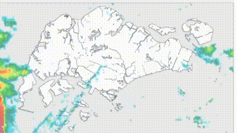
A Sumatra squall passing over Singapore in the span of two hours on the evening of Sep 17, 2024.
Dr Wang added that on average, squalls occur five to 10 times per month during these peak seasons.
According to a 2020 report by the Meteorological Service Singapore, the country experiences 45 squalls per year on average.
Squalls often occur in the pre-dawn hours or early morning.
What was its impact on Tuesday night?
Experts agreed that the wild weather on Tuesday night bore characteristics of a Sumatra squall.
Wind gusts caused by Sumatra squalls can be strong enough to uproot trees and cause property damage, as observed on Tuesday night.
A Bishan resident told CNA that shop shelves came crashing down and items that were unsecured were blown over.
“People actually hunkered down in shops for a few minutes because on the corridors it was way too windy and dangerous," the resident added.
According to Dr Wang, a five-minute rainfall totalling 11.4mm (equivalent to 137mm per hour) and a 10-minute average wind speed of 26.3 knots (equivalent to 48.7kmh) were recorded.
"These conditions are typically associated with typhoon-like severity," he added.
Tuesday's squall may also have been intensified by Typhoon Bebinca, which acted as a “pump” by amplifying the southwesterly winds, Dr Wang said.
“Such enhancement of wind flow could contribute to the rapid development and swift progression of the squall,” he told CNA.
Dr Dhrubajyoti Samanta, a senior research fellow at the Earth Observatory of Singapore at Nanyang Technological University (NTU), said Tuesday's squall was a rare one, given that such weather phenomenon usually happens in the pre-dawn and early morning periods.
"Satellite images show that yesterday evening there was a presence of strong convective clouds from the eastern Indian Ocean to the Philippines, which might have a strong role in the duration of storms and rains," he said.
"The presence of a low-pressure system in the western Pacific Ocean might have fuelled the migration of eastward to north-eastward moving cloud bands and wind."
How bad can a squall get?
Dr Wang from NIE said it is difficult to predict how bad squalls can get in the future.
This is the reason why the Centre for Climate Research Singapore (CCRS) is initiating the Weather Science Research Programme to improve weather prediction, he added.
In July 2014, a particularly severe Sumatra squall hit Singapore, producing winds of speed as high as 103.7kmh, leaving behind fallen trees and collapsed tents on parts of the island.
NParks said in response to queries from CNA that it "was alerted to tree incidents in various parts of Singapore" on Tuesday evening.
"Our staff and contractors worked through the night to clear the obstructions, and we are following up to clear any remaining debris," it said on Wednesday.
Will it affect flights?
Squalls can be “extremely hazardous” to aviation safety, particularly during landing and take-off, said Dr Wang.
"Aircraft can encounter sudden and intense turbulence due to the rapid changes in wind speed and direction associated with squalls. This phenomenon, known as wind shear, can cause planes to experience abrupt shifts in altitude and velocity, making it difficult for pilots to maintain control," he added.
However, Dr Roth from NUS pointed out that squall lines can be identified “relatively easily” and tracked on weather radar images, which provide sufficient time for flights to adjust their routes.
Shipping along the Strait of Malacca - one of the world's key shipping lanes - may also be affected.
No comments:
Post a Comment